FREE DELIVERY TODAY - Place your 1st order.

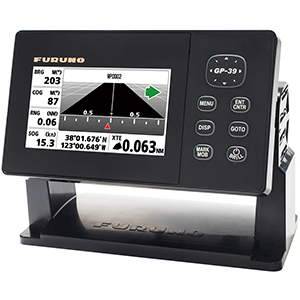
Furuno GP39 GPS/WAAS Navigator w/4.2 Color LCD
Consuming just 3 Watts at 12V/24V, this Furuno GP39 satellite receiver tracks 12-channel parallel WAAS fixes within 3 meters, plotting 10,000 waypoints on a 4.2-inch color LCD with USB backup at 0.86 lbs.
- WAAS differential achieves sub-3-meter position accuracy
- 4.2-inch color TFT display stops glare
- USB port backs up waypoint data
- IPX6 waterproof antenna survives coastal washdowns
Products are almost sold out
available only:
9In Stock
Description
The Furuno GP-39 is a compact dedicated GPS navigator with a 4.2-inch color LCD, internal 12-channel GPS receiver, and external GPS antenna. It provides position, course, speed, waypoint, route, track, steering, highway, and navigation-data display modes for recreational and smaller commercial vessels. This is a GPS navigator and track plotter, not a chartplotter with electronic-chart-card support, sonar, fish finder, radar, AIS receiver, or NMEA 2000 device.
The GP-39 supports WAAS, EGNOS, and MSAS augmentation where available, stores up to 10,000 waypoints, 100 routes with up to 30 points each, and 3,000 track points. It offers two NMEA 0183 serial ports and a USB port for data backup. The unit operates from 12V or 24V DC and can be installed using a bail bracket or optional flush-mount kit.
Key Specifications
- Compact Furuno GPS navigator and track plotter, model GP-39.
- Uses a 4.2-inch sunlight-viewable color TFT LCD with 480 by 272 pixel resolution.
- Uses a 12-channel parallel GPS receiver with WAAS, EGNOS, and MSAS support where available.
- Provides a one-second GPS position update interval.
- Stores up to 10,000 waypoints, 100 routes with up to 30 points each, and 3,000 track points.
- Provides two NMEA 0183 input and output ports plus USB backup connection.
- Operates from 12V or 24V DC with listed power consumption of approximately 3W.
- Uses IP55 display protection and an IPX6-rated antenna, with bail or optional flush mounting.
System Integration
The GP-39 can provide GPS position, course, speed, time, waypoint, and navigation data to compatible NMEA 0183 autopilots, VHF radios, AIS devices, or other marine electronics. It does not provide NMEA 2000 connection, built-in sonar, chart-card support, Wi-Fi, Bluetooth, radar control, or electronic chartplotter functions.
WAAS, EGNOS, and MSAS performance depends on regional coverage, satellite availability, reception quality, and correct antenna installation. Electronic navigation aids do not replace official charts, local notices, safe navigation practices, or a proper lookout.
Installation Considerations
Mount the display where it remains readable and protected from excessive spray, with sufficient rear clearance for power and NMEA 0183 cables. Install the supplied GPS antenna with an unobstructed view of the sky and away from radar, high-power transmitters, exhaust, alternators, engine wiring, and other interference sources. Confirm voltage supply, NMEA 0183 sentence settings, baud rate, route data transfer, and position reception before use.
Before Ordering
Confirm that a standalone GPS navigator without chart cards or sonar meets your needs, verify the supplied antenna and NMEA 0183 requirements, available 12V or 24V supply, bail or flush-mount preference, display and antenna mounting locations, waypoint and route capacity, cable-routing needs, and complete navigation-system requirements before purchase.
You must be logged in to post a review.


Reviews
There are no reviews yet.