FREE DELIVERY TODAY - Place your 1st order.


Garmin GPSMAP 9224 24″ Navionics+ Yacht Chartplotter
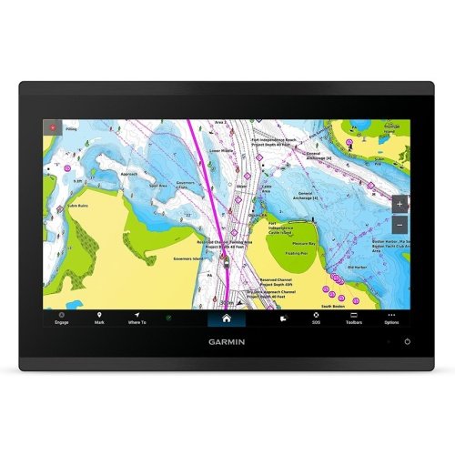
Plotting high-speed routes across 4K resolution glass helms, a Garmin GPSMAP 9224 chartplotter receiver samples 10Hz multi-band satellite data on a 24-inch 3840×2160 IPS touchscreen, rendering Navionics+ charts over BlueNet Gigabit ports at 20.1 lbs.
- 24-inch 4K touchscreen delivers 3840×2160 pixel resolution
- 10Hz multi-band positioning core eliminates map lag
- Preloaded Garmin Navionics+ charts guide coastal passages
- BlueNet Gigabit ports speed multi-station data sharing
- OneHelm interface centralizes onboard digital switching
Products are almost sold out
available only:
6In Stock
Description
The Garmin GPSMAP 9224 is a 24-inch 4K yacht chartplotter built for a helm where a normal MFD no longer gives enough space for charts, radar, cameras, and vessel data. Garmin Navionics+ coastal and inland mapping is preloaded, making it ready for supported waters on large luxury yachts, offshore sportfishers, and mega-center consoles.
The 3840 x 2160 IPS touchscreen carries far more chart detail than a Full HD display, which matters when several navigation windows are open at once. Its 10Hz multi-band positioning core supports fast navigation updates, while Garmin BlueNet Gigabit, NMEA 2000, NMEA 0183, J1939, and OneHelm support a large connected vessel system. This is a glass bridge navigation display, not a bundled fishfinder; the supplied information does not identify built-in sonar or a transducer.
Key Features
- 24-inch 4K IPS touchscreen – Gives charts, radar, and vessel systems an exceptionally large working area.
- 3840 x 2160 resolution – Shows high-detail chart and navigation information across the bridge.
- Garmin Navionics+ coastal and inland mapping – Includes compatible chart coverage for supported waters.
- 10Hz multi-band positioning – Provides the stated fast position-update capability.
- Garmin BlueNet, NMEA 2000, NMEA 0183, J1939, and OneHelm – Supports an integrated premium yacht system.
Who Is This For?
This 24-inch yacht chartplotter suits 40- to 90-foot luxury yachts, offshore sportfishers, and large center consoles with a dedicated glass bridge. It is not for a small boat, simple retrofit, or buyer expecting bundled sonar hardware.
Compatibility
Confirmed compatibility includes Garmin Navionics+, GPS, GLONASS, Galileo, QZSS, BeiDou, Garmin BlueNet Gigabit, NMEA 2000, NMEA 0183, J1939, and OneHelm. The supplied information does not identify sonar, radar, autopilot, WiFi, Bluetooth, or specific module compatibility. No named incompatible system was provided.
Technical Specifications
- Brand: Garmin
- Model: GPSMAP 9224, 010-02858-00
- Display: 24-inch 4K IPS touchscreen
- Resolution: 3840 x 2160 pixels
- GNSS: GPS, GLONASS, Galileo, QZSS, BeiDou
- Positioning: High-rate 10Hz multi-band core
- Charts: Garmin Navionics+ coastal and inland mapping
- Networking: Garmin BlueNet, NMEA 2000, NMEA 0183, J1939, OneHelm
- Power draw: 5.2A at 12V
- Water rating: IPX7
Warranty & Support
The supplied specifications do not state a warranty term. Confirm current Garmin warranty coverage before purchase.
The GPSMAP 9224 is for a bridge where maximum chart detail and screen space are worth the installation commitment. Compared with Full HD 22- or 24-inch units, the main gain is 4K detail. The trade-off is obvious: it needs a large cutout, a strong network plan, and a vessel substantial enough to use it properly.
| Brand | Garmin |
| Full Model SKU/Code | 010-02858-00 (GPSMAP 9224) |
| Country of Origin | Taiwan |
| Device Type | Premium Fixed-Mount Glass Bridge Multi-Function Display (MFD) |
| GNSS Systems Support | GPS, GLONASS, Galileo, QZSS, BeiDou |
| Receiver Channels & Frequency | High-Rate 10 Hz Multi-Band Positioning Core |
| Preloaded Marine Charts | Garmin Navionics+ Coastal and Inland Mapping Arrays |
| Display Technology & Resolution | Ultra-Bright 4K Touchscreen IPS Display Screen / 3840 x 2160 |
| Screen Size | 24.0" Diagonal Window |
| Interface Type | Capacitive Multi-Touch Interface Screen |
| Waypoint & Route Capacity | 5,000 Waypoints / 100 Routes |
| Internal Memory & Expansion | Integrated High-Speed Core SSD / Network Card Reader Compatible |
| Operating Voltage | 10 to 32 Volts DC Universal Rail Interface |
| Data Networking Protocols | Garmin BlueNet Gigabit Network Ports, NMEA 2000, NMEA 0183, J1939 Engine Bus, OneHelm Interface |
| Waterproof & Floating Rating | IPX7 Extreme Deck Front Panel Surface Armor |
| Maximum Current Draw | 5.2 Amps at 12V DC Input Loop |
| Dry Weight | 9.1 kg / 20.1 lbs |
| Application | Flagship helm glass-bridge matrix systems on large luxury superyachts, custom mega-yachts, and offshore mega-center consoles (40-90+ ft boat lengths) |
You must be logged in to post a review.



Reviews
There are no reviews yet.