FREE DELIVERY TODAY - Place your 1st order.


Furuno GP170 IMO GPS Navigator
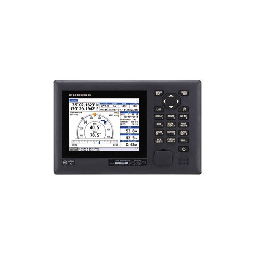
Wheelhouse bridge consoles gain IMO-compliant positioning from a Furuno GP170 GPS navigator, which tracks 12-channel parallel SBAS signals at 10 Hz across a 5.7-inch color display, outputting Ethernet and four serial ports at 4.85 lbs.
- 12-channel parallel engine updates at 10Hz
- SBAS differential maintains sub-5-meter position accuracy
- Numeric keypad allows rapid waypoint entry
- Ethernet LAN port integrates shipboard networks
- 2,000-waypoint memory saves commercial passage plans
Products are almost sold out
available only:
5In Stock
Description
The Furuno GP-170 is a professional GPS navigator for commercial vessels requiring a dedicated position, route, waypoint, and track display. It combines a 5.7-inch VGA color LCD, numeric keypad, internal GPS receiver, and bridge-compatible data interfaces in one unit. This is a GPS navigator rather than a chartplotter, fish finder, radar display, AIS receiver, or ECDIS system.
The GP-170 provides 10 Hz position updates and supports SBAS corrections where available. It stores up to 2,000 waypoints, 100 routes with up to 99 points each, and 2,000 track points. The navigator supports IEC 61162/NMEA 0183 serial data exchange and IEC 61162-450 Ethernet connections for compatible bridge electronics. DGPS capability requires an optional suitable differential-beacon receiver arrangement.
Key Specifications
- Professional Furuno GPS navigator for commercial-vessel navigation applications.
- Uses a 5.7-inch 640 by 480 pixel VGA color LCD with numeric and function keypad.
- Provides a 10 Hz GPS position update rate with SBAS support where available.
- Stores up to 2,000 waypoints, 100 routes with up to 99 points each, and 2,000 track points.
- Does not include internal DGPS beacon reception; verify optional DGPS requirements separately.
- Provides four IEC 61162/NMEA 0183 outputs, two inputs, and IEC 61162-450 Ethernet connectivity.
- Operates from 12V or 24V DC with a listed maximum power consumption of 20W.
- Measures approximately 248 mm by 172 mm by 156 mm, weighs approximately 2.2 kg, and supports desktop, overhead-bracket, or flush mounting.
System Integration
The GP-170 can send position, speed, course, time, waypoint, and route data to compatible bridge systems using IEC 61162/NMEA 0183 and Ethernet interfaces. It is not a chartplotter and does not replace official charts, local notices, navigation planning, radar, AIS, safe operation, or a proper lookout.
SBAS performance depends on regional coverage, satellite reception, antenna placement, and operating conditions. Confirm whether an optional DGPS receiver, compatible GPS antenna, external alarm system, serial-interface format, or Ethernet bridge-network connection is required for the vessel installation.
Installation Considerations
Mount the display at a protected bridge position with sufficient viewing angle, keypad access, and rear cable clearance. Mount the GPS antenna with a clear view of the sky and away from radar transmitters, VHF antennas, exhaust, high-current cables, and electromagnetic interference. Verify output sentences, baud rate, Ethernet configuration, position accuracy, alarm functions, and connected bridge-equipment operation during commissioning.
Before Ordering
Confirm GPS antenna requirements, optional DGPS requirement, local SBAS coverage, IEC 61162/NMEA 0183 and Ethernet interface needs, available 12V or 24V supply, desktop, overhead, or flush-mount space, cable-routing requirements, connected bridge-equipment compatibility, regulatory requirements, and complete commercial-navigation installation requirements before purchase.
You must be logged in to post a review.



Reviews
There are no reviews yet.