FREE DELIVERY TODAY - Place your 1st order.

Garmin GPSMAP 9017 Premium Chartplotter w/Worldwide Basemap
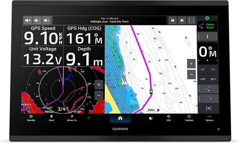
Slicing through blinding sun at 1200 nits, the Garmin GPSMAP 9017 chartplotter receiver runs a BlueNet processor on a 17-inch 1080p IPS touchscreen, displaying worldwide basemaps with HDMI video ports at 4.0A across 5.2 kg.
- 17-inch Full HD screen prevents glare
- 1200-nit brightness stops midday screen washout
- BlueNet Gigabit ports speed data sharing
- IPX7 waterproof construction withstands deck washdowns
Products are almost sold out
available only:
4In Stock
Description
The Garmin GPSMAP 9017 gives a large offshore helm the same 17-inch Full HD screen and BlueNet platform as the charted 9217, but starts with a Worldwide Basemap. That makes it useful for a custom Garmin installation where the owner plans to choose detailed charts and external sonar hardware around the boat’s actual cruising and fishing grounds.
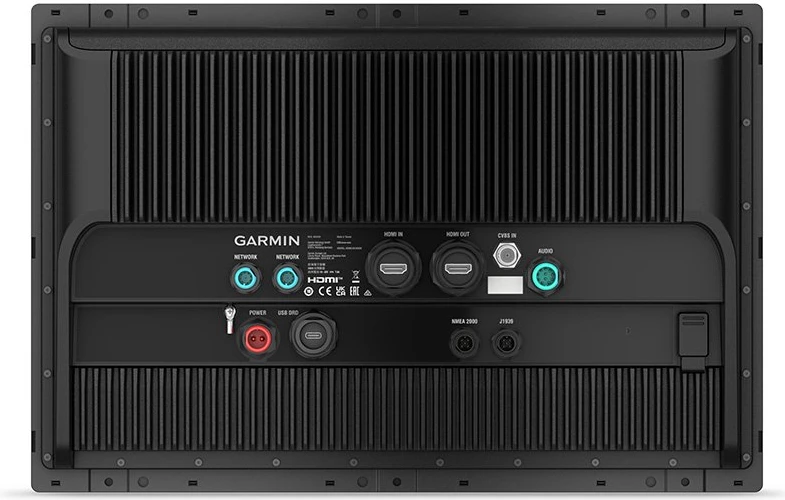
The anti-glare IPS display runs at 1200 nits, giving the operator a bright surface for charts, radar, camera feeds, and engine pages. BlueNet, HDMI, USB-C, NMEA 2000, NMEA 0183, WiFi, Bluetooth, and ANT+ make it a serious network hub. It does not have built-in sonar, so compatible BlueNet or GSD sounder hardware is needed. This is a system display for a planned bridge, not a simple replacement plotter.
Key Features
- 17-inch IPS touchscreen – Gives a large helm useful chart and system-data space.
- 1920 x 1080 Full HD resolution – Keeps split-screen views clear.
- 1200-nit brightness – Helps daylight readability.
- Worldwide Basemap – Provides global reference mapping before regional charts are selected.
- BlueNet, HDMI, USB-C, NMEA, WiFi, Bluetooth, and ANT+ – Supports a connected Garmin bridge system.
Who Is This For?
This large Garmin chartplotter suits offshore boats, luxury cruisers, and multi-display helms with a custom chart and sonar plan. It is not ideal for buyers who need regional charts or a complete fishfinder immediately.
Compatibility
Confirmed compatibility includes BlueNet/GSD sonar modules, Worldwide Basemap, NMEA 2000, NMEA 0183, HDMI input/output, USB-C, WiFi, Bluetooth, and ANT+. No specific radar, autopilot, or transducer model is named. No named incompatible system was provided.
Technical Specifications
- Brand: Garmin
- Model: GPSMAP 9017, 010-02641-00
- Display: 17-inch IPS touchscreen
- Resolution: 1920 x 1080 Full HD
- Brightness: 1200 nits
- Charts: Worldwide Basemap
- Sonar: External BlueNet/GSD network sonar support
- Networking: BlueNet, HDMI input/output, USB-C, NMEA 2000, NMEA 0183, WiFi, Bluetooth, ANT+
- Power draw: 4.0A at 12V
- Water rating: IPX7
Warranty & Support
Garmin provides a 2-year standard warranty. The supplied specifications do not state exclusions or service procedures.
The GPSMAP 9017 is for the owner who wants the premium 17-inch Garmin platform but prefers to choose charts and sonar separately. Compared with the 9217, the trade-off is preloaded chart coverage. Choose this version for a custom bridge system, not when Navionics+ is needed from day one.
| Brand | Garmin |
| Model Name | GPSMAP 9017 |
| Part Number/SKU | 010-02641-00 |
| Technology Category | Premium Glass Helm MFD |
| Display Size & Type | 17" IPS Touchscreen |
| Resolution | 1920 x 1080 pixels (Full HD) |
| Brightness | 1200 nits |
| Processor/Engine | Garmin BlueNet Ultra-High Speed Processor |
| Operating System | Garmin Marine OS (9000 Series) |
| Sonar Compatibility | Network Sonar Support via BlueNet/GSD Modules |
| Mapping/Charts | Worldwide Basemap |
| NMEA Interface | NMEA 2000, NMEA 0183 |
| Networking Ports | Multiple BlueNet Ports, 1x HDMI In, 1x HDMI Out, 1x USB-C |
| Wireless | Wi-Fi, Bluetooth, ANT+ |
| Voltage Input | 10 - 32 V DC |
| Power Draw | 4.0 Amps @ 12V |
| Waterproofing | IPX7 |
| Physical Dimensions | 419 x 307 x 82 mm |
| Cut-out Dimensions | 395 x 283 mm |
| Weight | 5.2 kg |
| Country of Origin | Made in Taiwan |
| Standard Warranty | 2 Years |
You must be logged in to post a review.




Reviews
There are no reviews yet.