FREE DELIVERY TODAY - Place your 1st order.


Garmin GPSMAP 1623 16″ Marine Chartplotter Display
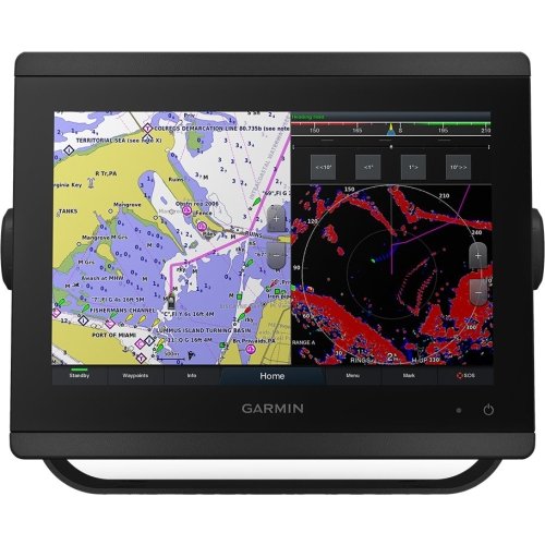
The Garmin GPSMAP 1623 16″ Marine Chartplotter Display, from Garmin, is suited for Main command consoles on mid-to-large offshore fiberglass fishing hulls, high-performance cruisers, and multi-display premium dashboards (26-55 ft hulls).
- Waterproof & Floating Rating: IPX7 Waterproof Protection Architecture.
- Dry Weight: 4.4 kg / 9.6 lbs.
- Device Type: Fixed-Mount Marine Chartplotter Multi-Function Display (MFD).
- GNSS Systems Support: GPS, GLONASS, Galileo, QZSS, BeiDou.
- Screen Size: 15.6″ Diagonal Window Display Surface.
Products are almost sold out
available only:
5In Stock
Description
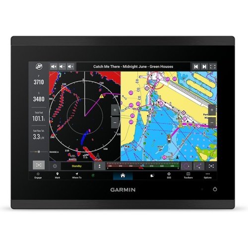
On a 30-foot sportfisher or fast cruiser, there is a point where a normal 12-inch display stops being enough for safe, comfortable split-screen work. The Garmin GPSMAP 1623 gives the helm a 15.6-inch Full HD chartplotter display with preloaded Garmin Navionics+ coastal and inland mapping. It is aimed at boats that need charts and system data clearly visible from a standing position.
Its 10Hz multi-band positioning core matters when following a route at speed, because the display receives more frequent position updates than a basic GPS plotter. The 1920 x 1080 IPS screen gives chart details and data panels more separation, while Garmin Marine Network, NMEA 2000, NMEA 0183, J1939, and OneHelm connections support a wider helm system. This model is chartplotter-focused; the supplied specifications do not list built-in sonar or a transducer, so fishfinding needs separate compatible hardware.
Key Features
- 15.6-inch Full HD IPS touchscreen – Gives charts, radar, and vessel data enough room on a premium helm.
- 1920 x 1080 resolution – Keeps dense chart and split-screen information clear.
- 10Hz multi-band positioning – Delivers the listed fast position-update capability for navigation.
- Garmin Navionics+ coastal and inland mapping – Includes chart coverage for supported waters.
- Garmin Marine Network, NMEA 2000, NMEA 0183, J1939, and OneHelm – Supports a connected marine electronics system.
Who Is This For?
This large marine chartplotter display suits 26- to 55-foot offshore fishing boats, high-performance cruisers, and premium multi-display dashboards. It is not ideal for a compact helm or anyone expecting an included fishfinder; no built-in sonar or transducer is listed.
Compatibility
Confirmed compatibility includes Garmin Navionics+, GPS, GLONASS, Galileo, QZSS, BeiDou, Garmin Marine Network, NMEA 2000, NMEA 0183, J1939, and OneHelm. No specific sonar module, transducer, radar, or autopilot model is named. No named incompatible system was provided.
Technical Specifications
- Brand: Garmin
- Model: GPSMAP 1623, 010-02861-00
- Display: 15.6-inch Full HD IPS touchscreen
- Resolution: 1920 x 1080 pixels
- Charts: Garmin Navionics+ coastal and inland mapping
- GNSS: GPS, GLONASS, Galileo, QZSS, BeiDou
- Positioning: High-rate 10Hz multi-band core
- Networking: Garmin Marine Network, NMEA 2000, NMEA 0183, J1939, OneHelm
- Power draw: 3.3A at 12V; 46.5W maximum
- Water rating: IPX7
Warranty & Support
The supplied specifications do not state a warranty term. Confirm current Garmin warranty coverage before purchase.
The GPSMAP 1623 sits between compact MFDs and full glass bridge displays. It is the right choice when a large chart screen is more important than an included sounder. The trade-off is system planning: Garmin Navionics+ mapping is already there, but sonar hardware must be selected separately. That makes it a better fit for a planned premium helm than a quick fishfinder replacement.
| Brand | Garmin |
| Full Model SKU/Code | 010-02861-00 (GPSMAP 1623) |
| Country of Origin | Taiwan |
| Device Type | Fixed-Mount Marine Chartplotter Multi-Function Display (MFD) |
| GNSS Systems Support | GPS, GLONASS, Galileo, QZSS, BeiDou |
| Receiver Channels & Frequency | High-Rate 10 Hz Multi-Band Positioning Core |
| Preloaded Marine Charts | Garmin Navionics+ Coastal and Inland Mapping Arrays |
| Display Technology & Resolution | Bright Full HD (FHD) In-Plane Switching (IPS) Multi-Touch Screen / 1920 x 1080 |
| Screen Size | 15.6" Diagonal Window Display Surface |
| Interface Type | Capacitive Multi-Touch Interface Screen |
| Waypoint & Route Capacity | 5,000 Waypoints / 100 Routes |
| Internal Memory & Expansion | Integrated Internal Flash Memory / Dual MicroSD Card Slot Hub Layout |
| Operating Voltage | 10 to 32 Volts DC Universal Rail Interface |
| Data Networking Protocols | Garmin Marine Network Ethernet (Multiple Ports), NMEA 2000, NMEA 0183, J1939 Engine Can Bus, OneHelm Connectivity |
| Waterproof & Floating Rating | IPX7 Waterproof Protection Architecture |
| Maximum Current Draw | 3.3 Amps at 12V DC Input Loop (Max Power Draw: 46.5W) |
| Dry Weight | 4.4 kg / 9.6 lbs |
| Application | Main command consoles on mid-to-large offshore fiberglass fishing hulls, high-performance cruisers, and multi-display premium dashboards (26-55 ft hulls) |
You must be logged in to post a review.







Reviews
There are no reviews yet.